Can MapToNap show shadows at a specific hour?
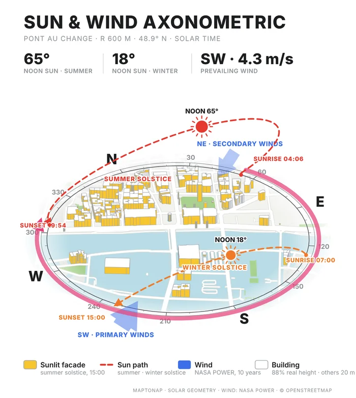
The massing and Sun & Wind Axonometric sheets show shadows and sunlit facades for set solar positions. For scrubbing through any hour in 3D, a shadow viewer is the better tool.
Shadow viewers show real-time sun and shadows on a 3D map of the city. MapToNap draws sun paths, sun and wind axonometrics, massing with shadows and climate charts as editable sheets for a site-analysis set. This page is written by the MapToNap team. We compare kinds of tool rather than named products, and describe each by what it does best.
| 3D shadow viewers | MapToNap | |
|---|---|---|
| Core job | Interactive 3D sun and shadow simulation | Sun, wind and climate drawings for presentation |
| Sun and shadow | Live shadows through any hour and date (often on paid plans) | Sun path, Sun & Wind Axonometric (solstice paths, sunlit facades), massing with shadows |
| Wind and climate | Rarely included | Wind rose, wind flow around blocks, temperature, rainfall, solar radiation |
| Output | A live view, sometimes shareable | Editable SVG, vector PDF, PNG |
| Typical pricing | Free basic view; paid monthly plans for dates and analytics | Four drawings free (watermarked, no sign-up); Pro €7.99 or Max €12.99 for 30 days, Max for a year €49. One-off passes, nothing renews. |
Checked 25 October 2026. The left column describes what tools of this kind typically offer; individual products differ, so check the one you are considering. Features and prices change.
You need to see exactly when a façade is in shade on a given day, or show a client a live view.
You need sun and climate drawings that sit on a board next to the other analyses.
Find the critical dates in a viewer; draw the conclusions as sheets.
Use the viewer to check, MapToNap to present.
MapToNap adds wind, temperature and rainfall for the same site.
Both kinds of tool usually have a free version.
The massing and Sun & Wind Axonometric sheets show shadows and sunlit facades for set solar positions. For scrubbing through any hour in 3D, a shadow viewer is the better tool.
MapToNap: every sheet exports as editable SVG and vector PDF.
From long-term weather records for the site's location; the sheet states the source.
If sun is the main design driver, a viewer is worth adding; for a complete set, MapToNap covers sun alongside the rest.